MIRACLE OF THE MEDIEVAL EAST
Just buy a ticket to Ordubad to see it
Author: Aynur TALIBOVA Ordubad
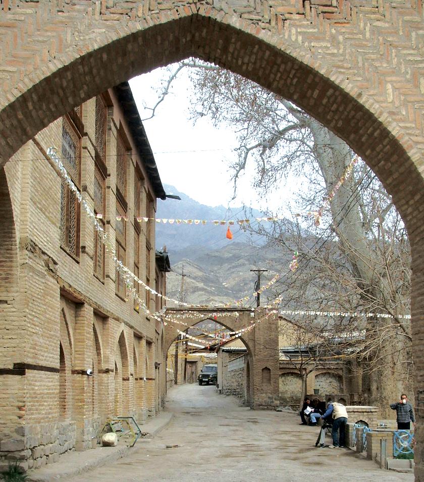
The town is made up of neighbourhoods, each of which has its own square, mosque, pool, spring, plane trees and bath house. Bearing in mind that during the Soviet era just one mosque functioned in Baku, it's remarkable that every neighbourhood has a mosque in Ordubad. The mosque here is a place where people gather to meet and talk as well as to worship. The whole neighbourhood converges here for funerals and charitable events.
Main neighbourhood
The Sersahar neighbourhood is the largest in Ordubad. Translated from Persian, its name means "main town". Sersahar is also the oldest neighbourhood on the left bank of the Ordubadcay River so it has the largest number of old buildings. The two storey neighbourhood mosque, square, pool, spring, bath house and thousand-year-old double plane tree - the whole area has kept its 18th century style. The neighbourhood is in the centre of town so every road passes through it.
Ambaras neighbourhood
Located on the right bank of the Ordubdcay, Ambaras consists of two ancient neighbourhoods, Lower and Upper Ambaras. It is referred to in written sources from the 18th century. The neighbourhood mosque (17th -18th century), spring and several small shops are in the centre. The whole square is in the shade of ancient plane trees. The old men of this picturesque neighbourhood say that long ago the neighbourhood was called Abirasd, which translates from Persian as "with many waters". There are a great many springs here.
Mingis neighbourhood
The neighbourhood is famed for its 9th century mosque. The house where famous writer Mammad Said Ordubad was born is here. The name of the neighbourhood is interpreted as "min kas" or "one thousand people". Local elders say that 1,000 people used to live here, hence the name. In fact, 1,000 is one of the symbolic numbers (with 3, 7 and 40) found in oriental folklore, the poetic sense of which is a large number.
Mingis is also famed for its sabaka workshops. The most famed master craftsman is Cabir, and orders can be placed in his workshop. Ordubad is the second place after Saki where this ancient craft continues in Azerbaijan.
Ordubad sabaka
Famous architect Acami Abubakr oglu Naxcivani widely used sabaka for the first time in the 19th century in the mausoleum of Xaraba Gilan. Sabaka is present in all his historic works. Sabaka is widely used in Ordubad's historic buildings - Zorxana-Qeysariyya and the Cuma mosque (the main mosque). But unlike Saki craftsmen, Ordubad craftsmen use small nails in their sabaka.
Underground water supply or 40 steps
Ordubad is said to have had more than 70 springs in the 17th century. The system of underground water pipes, created in the Middle Ages, remains the main source of the town's water supply today. The people call the pipes, which are in the squares and some residential dwellings, the "40 steps" because steps have been dug to make access to the water easier.
As a piece of underground hydro-technical engineering, the water pipes became an important part of daily life as the source of the water supply. The pipes not only supplied drinking water, but powered mills, irrigated fields, gardens and kitchen gardens. They also served as refrigerators - grapes, melons, water melons, meat and grain were stored here in the summer months.
Lesser Caucasus
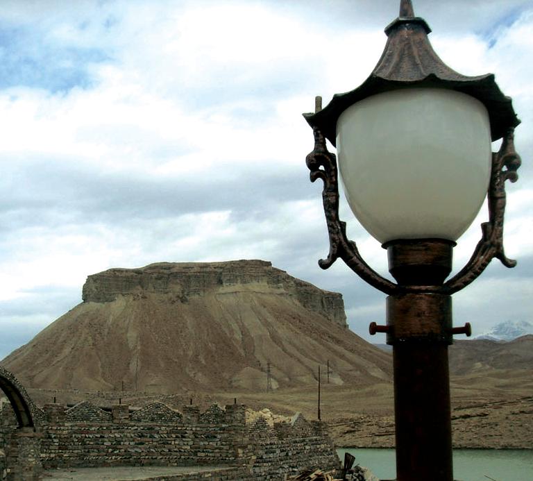
Ordubad is mostly mountainous or hilly. The highest peak in the Lesser Caucasus is here, Qapiciq. All the peaks in Naxcivan are named and have an ancient history. These names are linked either with the shape of the peak itself or with a legend. The shape of the mountain on the way into town, Plovdag, is eye-catching.
Plovdag
Local people say that the mountain got its name from its resemblance to a dish of pilaff or plov. The mountain on the left bank of the River Gilancay is 1,036 metres high. There are traces of an ancient Bronze Age culture here.
Xaraba Gilan
This is an ancient settlement covering more than 100 hectares near Plovdag. The town of Xaraba Gilan took shape in the 5th-4th centuries BC, but a settlement and necropolis have been found here dating back to 2,000-1,000 BC. This urban culture survived to the 14th century, undergoing a revival in the 10th-12th centuries. The Plovdag necropolis is more than 4,000 years old. In those days people settled close to the river for easy access to water and in higher places which were easy to defend. Plovdag was a very suitable spot in this regard. The population of Xaraba Gilan, which became a powerful, fortified position, were Turkic-speaking tribes. Researchers say that the town was badly damaged during the Mongol occupation, while a terrible earthquake in the 14th century flattened the town.
Aza village
This is the main centre to which people moved after the destruction of Xaraba Gilana. Several kilometres from the village, Der Gumbez (Der cupola) is the only historical monument from the 14th century. There are places in Ordubad linked with the great flood during the times of Noah. Tradition has it that Noah's youngest son, Yapheth (Yafes in Azerbaijani), is buried here. Nearby is the town of Yafes. People who visit the ruins today consider the place holy. Another famous historical monument in this village is Aza Bridge, which was built when the tsarist government was improving the area. A local merchant built the bridge over the River Gilan in 1826.
You need to travel in various directions to find out more about Ordubad. One route passes through the villages of Dirnis, Kalaki and Pazmari.
Dirnis village
The village is one of the holiday areas of Ordubad, in a location open on all sides. Hence the name Dirnis, which translates as "without doors". Dirnis, the first village in the area, has some 300 houses.
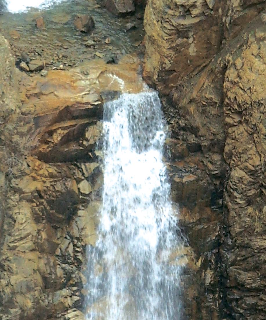
The view of the Zangezur Mountains in the Lesser Caucasus range is stunning. The sheer beauty of the area makes you get out of the car to enjoy it to the full. Boulders blocking the road make travel difficult and they need to be removed for a car to pass, otherwise you have to walk on foot up the River Kaplan. At the end of the journey the roar of the Kaplan waterfall disturbs the silence. The waterfall is approximately 40 minutes by car from Pazmari village. These areas, which are a picnic paradise in May, have rich gold seams.
Pazmari village
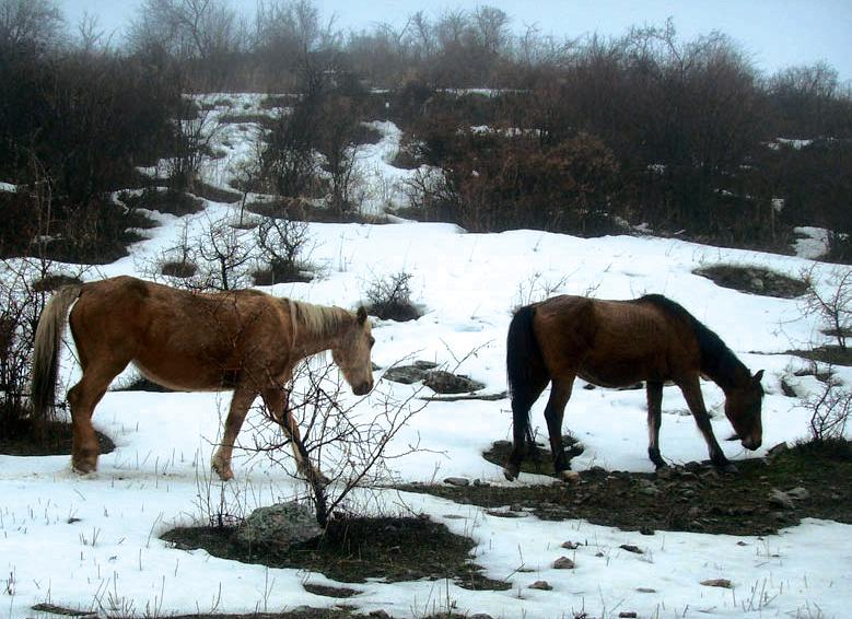
Pazmari, 30 kilometres north-west of the town, is Ordubad's mountain paradise. It is very cool here even in the hottest days of summer. Stock- rearing and bee-keeping have been practised here for centuries. The environment is just right for it. Pazmari with its 35 houses is the last inhabited place in this border area. The water comes from a mineral spring in the village and is packed with carbon, sulphurous bicarbonate, calcium and sodium. It is said to have medicinal properties.
The dried skulls of wild oxen, of which there are many here, hang from the wooden pillars in some of the houses. Local people sometimes hunt them. Ox meat is eaten and the skins are used about the house.
Kalaki village
This is one of the most beautiful mountain villages in the district, located 45 kilometres from the town of Ordubad. The name bears no relation to the word "kalak" meaning "lie" or "invention". It is thought to have come from the word "qala" (fortress) or "qalaca" (small fortress). Kalaki is famed for its gold deposits. The mines are 300 metres from the village and 145-1,550 metres above sea level. The ground is rich in other minerals too. Local people say that the population of the village moved here from Karabakh during the tsarist era. And Kalaki speech is similar to Karabakh dialect.
Another interesting trip in Ordubad is 60 kilometres to Nasirvaz and Gamiqaya. This area is indescribably beautiful. Every stone and every gorge has its own long history. The villages along the way are on the slopes of the Lesser Caucasus.
Bilav village
This is the first village in this direction, on the site of an ancient town. The jagged Mount Babak is the most famous site in this area. National hero Babak is thought to have lived here. The area was one of the stopping points on the Great Silk Road and the fortress here provided protection from bandits and robbers.
Tivi village
Tivi village is 60 km north-east of the town of Ordubad. There are interesting theories about the origin of the village's name. In Arabic the word "tiv" means "pleasant aroma" or "fragrant". Hundreds of fragrant plants grow in the mountains around Tivi and there is a huge number of mineral springs. One of them has Narzan-type water which is recommended for the treatment of skin disease.
The ancient Tivi necropolis was found in 1968 near to the village.
The craftsmen in Tivi who make wind instruments say that the zurna is especially valued. The zurna, made out of nut and apricot wood, is one of the oldest musical instruments. It is said to have been played in the era of the prophet Noah. Legend has it that before the flood a shepherd climbed a mountain and blew the zurna to signal the impending catastrophe. A tune by the name of Noah's Tune is still played here. And the zurna is one of the most resonant wind instruments.
Nasirvaz village
At 2,000 metres above sea level, this is the last inhabited spot in this direction. From November to April the area is covered in snow while mist is a frequent visitor in summer. The village of Nasirvaz is on the slopes of the highest peak in the Lesser Caucasus, Mount Gamiqaya. This is where Noah anchored his ark. This area is considered to be closer to the Almighty, Nabi yurdu. The village is said to have been named after the scholar Nasraddin Tusi (1201-74), "Nasir avaz" or "Nasir's voice". Bee-keeping and walnut-growing are the main sources of income for the local population.
All these villages have one thing in common - the larders that are an essential part of everyday life.
Larders
Food produce is not sold in the shops in mountain villages. All food is prepared at home. People have to stock up carefully for the long, cold winter. So that the produce does not spoil, it is kept in special larders beneath the houses, which are like supermarkets full of ecologically pure foodstuffs. There is everything here: hundreds of types of marinades, jams, juices, preserved vegetables, specially dried herbs, pure butter, sour cream, cheese, yoghurt, hundreds of pieces of lavash bread, many eggs, around a tonne of potatoes and onions and lamb and goat roasted according to a special recipe.
One of my favourite of all these products is the especially tasty Siberian roast. This is the roast meat of a six- to seven-year-old goat. Quite a large family can live for several months on these stocks without wanting for anything.
Walking through a larder gives you an appetite. At the same time you can't help wondering, "What's going on? Is the world about to end?" The answer is simple: the difficult geology of the area, the complex geography and the harsh natural conditions mean that food has to be stock piled.
During the long, cold winter evenings the women of the village weave large woollen shawls of a single colour, similar to carpets, which they richly decorate.
Gamiqaya
Scientific research has been under way at Gamiqaya since 1968. In 2006 it was given the status of an historic and artistic reserve. This peak in the Zangezur mountain chain is the oldest settlement on the territory of the Naxcivan Autonomous Republic. Gamiqaya's mountain plateau is considered a holy place. The temples here are found between cliffs permanently covered in snow. From a distance the peak looks like a ship sailing in the blue sky. This is why the highest peak (3,904 m) of the Lesser Caucasus is popularly known as Gamiqaya or Ship Mountain. The ancient tribes of Naxcivan lived on the Gamiqaya-Qaranqus plateau. There are cliff drawings here and ancient inscriptions dating back to the 3rd to 1st centuries BC. The drawings show people, different animals and ox hunting with bows and arrows.
Some of the ancient settlements and cliff drawings are said to be at least 5-6,000 years old while Mount Gamiqaya itself is traditionally linked to the legend of Noah.
Legend of Noah
Realizing that a flood was threatening the world, Noah built an ark and managed to save himself and the people and animals on the ark. According to the legend, during a storm Noah's ark hit the peak of Ilandag, in eastern Naxcivan, and Alangaz and Kamki in Ordubad and, finally, came to rest on Mount Gamiqaya. This legend shows the single roots of all the Sumerian and Jewish legends about Noah. Although the legend has been known since 3,000 BC, the Sumerians did not record it until around 1,500 BC. Many historians think that this coincides with the time that Naxcivan was founded (1,539 BC).
The legend says that fragments of the ark that came to rest on Mount Gamiqaya are still here in the Ayi cuxuru (Bear's Hollow). Scholars have noted the presence of ancient inscriptions about Noah on the cliffs of Gamiqaya.
It is better to come here in July and August if you want to visit Gamiqaya. This is the only time of year that it is possible to climb to the top and enjoy the beauty and majesty of the area.
Old traditions and customs are jealously guarded in Ordubad. This can be seen in the Axista, performed by a girls' folk group from Kalaki village school.
Axista
This musical game, associated with holiday traditions, is widespread in Naxcivan. Girls split into two groups and take turns to recite quatrains, after each line of which all the other girls say "axista" in unison, clap their hands and dance.
The women from the groom's family who come to meet the bride also take part in this tradition. According to tradition, they should bring gifts for the bride, a dress, a tray with gold decorations and sweets, wrapped in cellophane and tied with red ribbon.
The relatives of the groom praise him in unison. And the bride's relatives praise her just as much too. As soon as one side offends the other, the game becomes a friendly verbal duel.
Ordubad people are so hospitable that they will not allow guests to leave until they have fed them to the gills. I had an inkling that they would still know how to make some of the traditional Azerbaijani dishes here which have already been forgotten elsewhere. I was not disappointed and was lucky enough to try them.
Qurut and fried eggs Ordubad-style
For some reason I thought qurut was traditional only in the western regions of Azerbaijan, but they are popular in Ordubad's mountain villages too.
Qurut are hard balls made out of dried milk, or to be more exact, buttermilk. Before they are used, qurut are crumbled and dissolved in warm water. The water is then put over heat and stirred continuously until it comes to the boil. At the same time onions are fried in butter. Dried lavash is crumbled onto a plate, the qurut dissolved in water is poured over it, the fried onion is added and ground walnuts are sprinkled on top. This remarkably tasty dish is prepared once or twice a year in the depths of winter. Ordubad people, who know all about the origins and history of every dish, say that stock breeders always have an excess of milk and dairy products. They came up with this dish in order to use up excess buttermilk.
Talking about Ordubad, you have to mention Ordubad eggs. They are not just an omelette. Ordubad eggs on the plate look more like a pie. It takes quite a lot of time, effort and ingredients to prepare Ordubad eggs. Imagine an omelette made from 12 eggs, fried in a whole kilogram of butter with syrup of pure honey added. Unusual, don't you think?
Everything is unusual in Ordubad and has its own history. If you would like to see a real, medieval town, find out about colourful traditions, taste delicious eastern cuisine or simply relax in the bosom of nature, you can confidently buy a ticket to Ordubad.
RECOMMEND:
 701
701